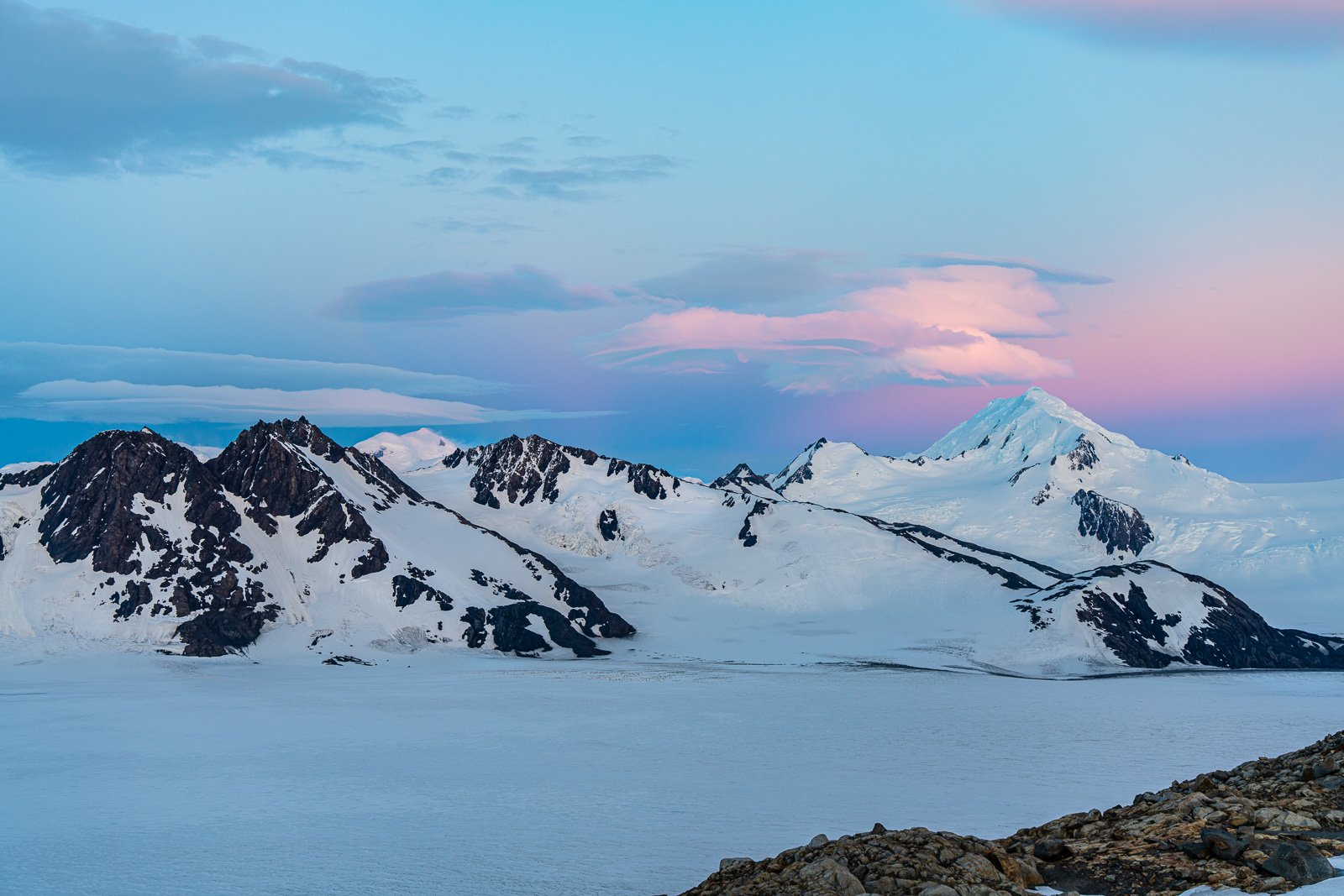
Sunset over the vast Southern Patagonian Ice Field, the world’s second largest contiguous extrapolar ice field. You won’t see this from any of the standard El Chalten Hikes!
Huemul Circuit El Chalten Patagonia Guide
Trekking around El Chalten is certainly a highlight of a trip to Patagonia. The standard treks to see Monte Fitz Roy, Cerro Torre, Lago Torre, and Laguna de Los Tres are worth the trip alone. But in our opinion, the true gem of going down to Patagonia, in either Argentina or Chile, is the opportunity to see the world’s second largest contiguous extrapolar ice field: the Southern Patagonian Ice Field. Surprisingly, due to the huge barrier of mountain chains (Monte Fitz Roy, Cerro Torre, etc.) between El Chalten and the ice field, there are few opportunities to actually see the ice shelf. On the standard hikes in the area you can see glaciers that are ice-rivers feeding off of the ice shelf — but you won’t see the vast ice shelf itself. So if you want to get a look at the real-deal 4,773 square miles (220 miles) of the Southern Patagonian Ice Field, then the Huemul Circuit is the only option in town.
Why This Guide?
This is a serious trek and needs a serious and accurate guide. As such, we’ve published this guide after finding other guides to this hike lacking essential information to successfully complete the trek. Most are missing critical information for the Huemul Circuit (some provide downright wrong info) and others give questionable advice on a number of issues. Finally, none of them have a decent .gpx track that you can use with a phone mapping app like GAIA GPS to greatly improve your naviaton and trip experiences. [Sorry folks, but Maps.me is woefully insufficient for hiking a serious route like the Huemul Circuit!] Our guide corrects all of these issues and provides a detailed GPX track for the Huemul Circuit. -alan & alison
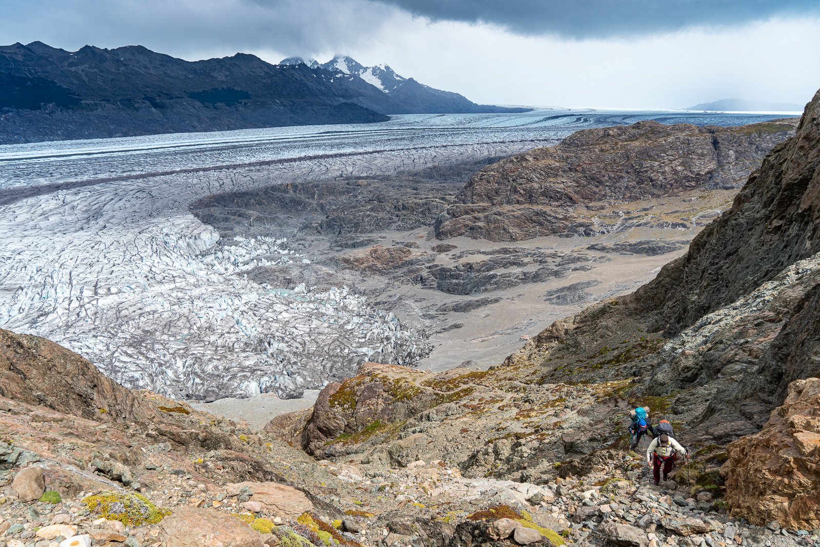
Hiking up Paso Huemul with the Viedma Glacier below, which flows from the vast Southern Patagonian Ice Field (top of picture in the far distance).
Huemul Circuit Hiking Guide
Top Things You Need to Know
Highlight – This the only hike out of El Chalten that gives mere-mortal-hikers views of the vast Southern Patagonian Ice Field, the world’s second largest contiguous extrapolar ice field. It is an awesome hike. You won’t get even a peek of the Southern Patagonian Ice Field on any of the standard hikes in the area.
Location – El Chalten, Argentina. Trek start is at the Park Visitor Center in town.
Season – October 1 through April 1 (summer in Patagonia).
Duration – 4 moderate to tough days
Distance – 58 km (36 miles). Total Ascent 2300 m (7500 ft) ↑ | Total Descent 2400 m (8000 ft) ↓
Navigation and Maps – We have provided a detailed .GPX file for the Huemul Circuit. As far as we know, it is the only one available. Do not use Maps.me. Instead we suggest you get GAIA GPS. A paper map of the park (get in town) is quite useful.
Permits/Fees – A free permit is required along with a mandatory gear check. Get both at the Park Headquarters.
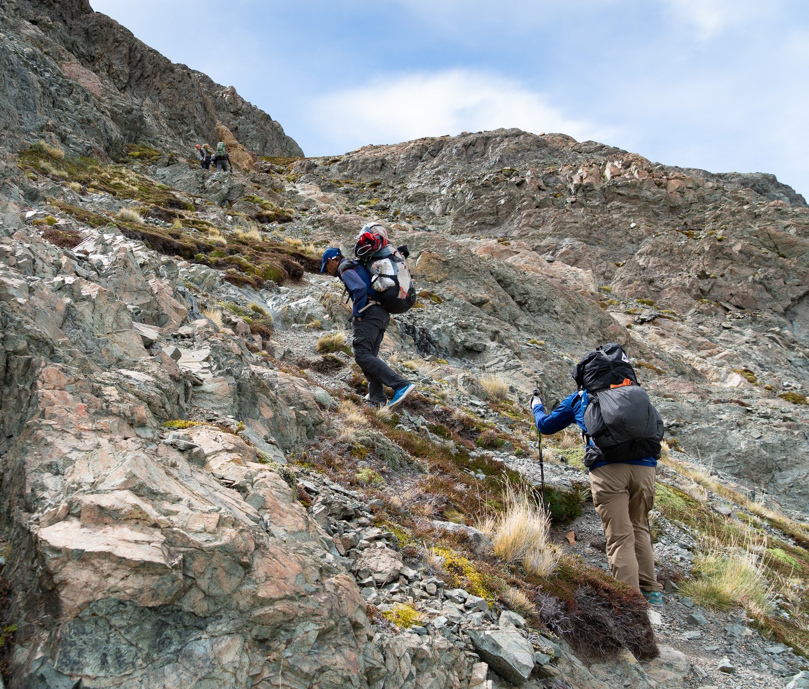
Level of Difficulty – Technical difficulty high — you need to rig and do two tyrolean traverses. Physical difficulty moderate to hard depending on wind, river levels, Patagonian weather and your level of comfort navigating on cruddy, loose glacial moraines and other junky footing.
Guided Option – Given the level of technical difficulty, there are several trekking companies in town that will happily take you on this trek. We recommend Casa del Guias, a long standing, locally owned and operated business in El Chalten with a great reputation.
Route Finding – Moderate to easy. The path is fairly straightforward and easy to follow much of the time. But it can suddenly vanish at other times. We suspect that it changes a bit every year. Keep our GPS TRACK with you to ensure your success.
Logistics: This trek is somewhat of a loop hike — but you will need to hitch or organize a ride from the endpoint back to town or hike some 8 km (5 miles) extra miles.
Challenges – Tyrolean traverses, cold glacial river crossings, and potentially some tough patagonian weather. Possibly the biggest challenge comes on day 3 where you have a slippery walk/slide down the side of a hill on some loose, massively eroding junk-conglomerate of cruddy rock and dirt. Trekking poles are essential! And of course patagonian wind can stop you in your tracks (literally) over Paso del Viento or Paso Huemul.
Personal Safety (Geographic) – This region of Argentina is totally stable and safe. There are lots of tourists safely trekking and vacationing here.
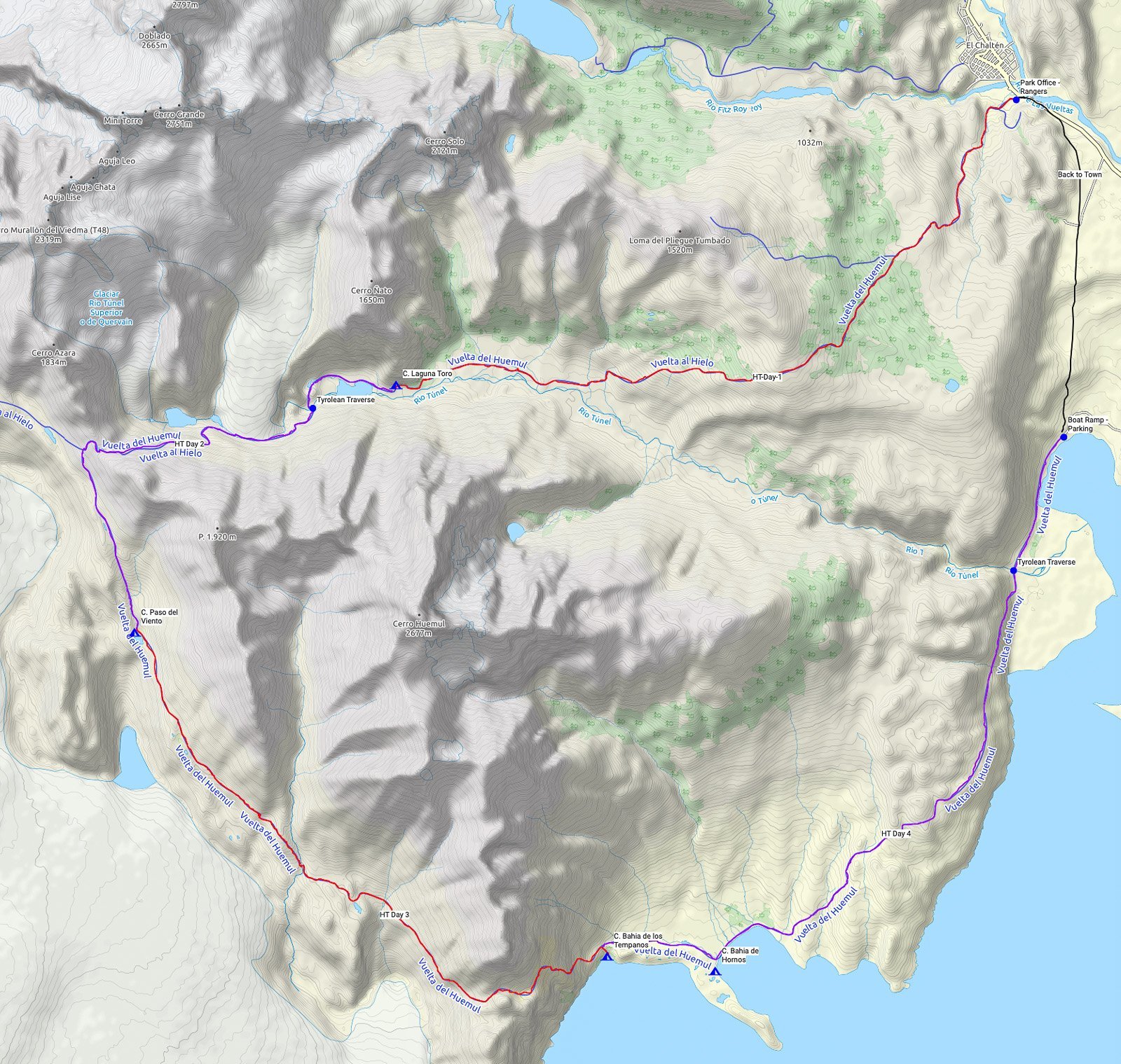
Huemul Circuit Hike overview map. [Click on map to enlarge.]
Gear, Food, Water and Camping
Gear – The right gear is essential. Patagonian weather can be harsh with frequent rain (or snow) and it’s legendary howling winds. This is a List of the Gear that has been refined by us in over 15 years of trekking in both Chilean and Argentinian Patagonia. It’s light and it works!
Camping – There is backcountry camping along this trail and no facilities. Laguna Toro has a very rudimentary toilet and Paso del Viento campground has a cooking hut but that’s it.
Water and Food – Water is plentiful along the trail and in backcountry camps but there is no treated water. As there is no food or other services available along this route, you will need to bring all food with you. For hiking food see 2019 Best Backpacking Food | simple and nutritious. Note: Drinking glacial fed water clouded with “rock flour” (glacial sediment) and should be avoided. It will clog your filter and its not great for your gut. There are plenty of clear running water sources available during this trek.
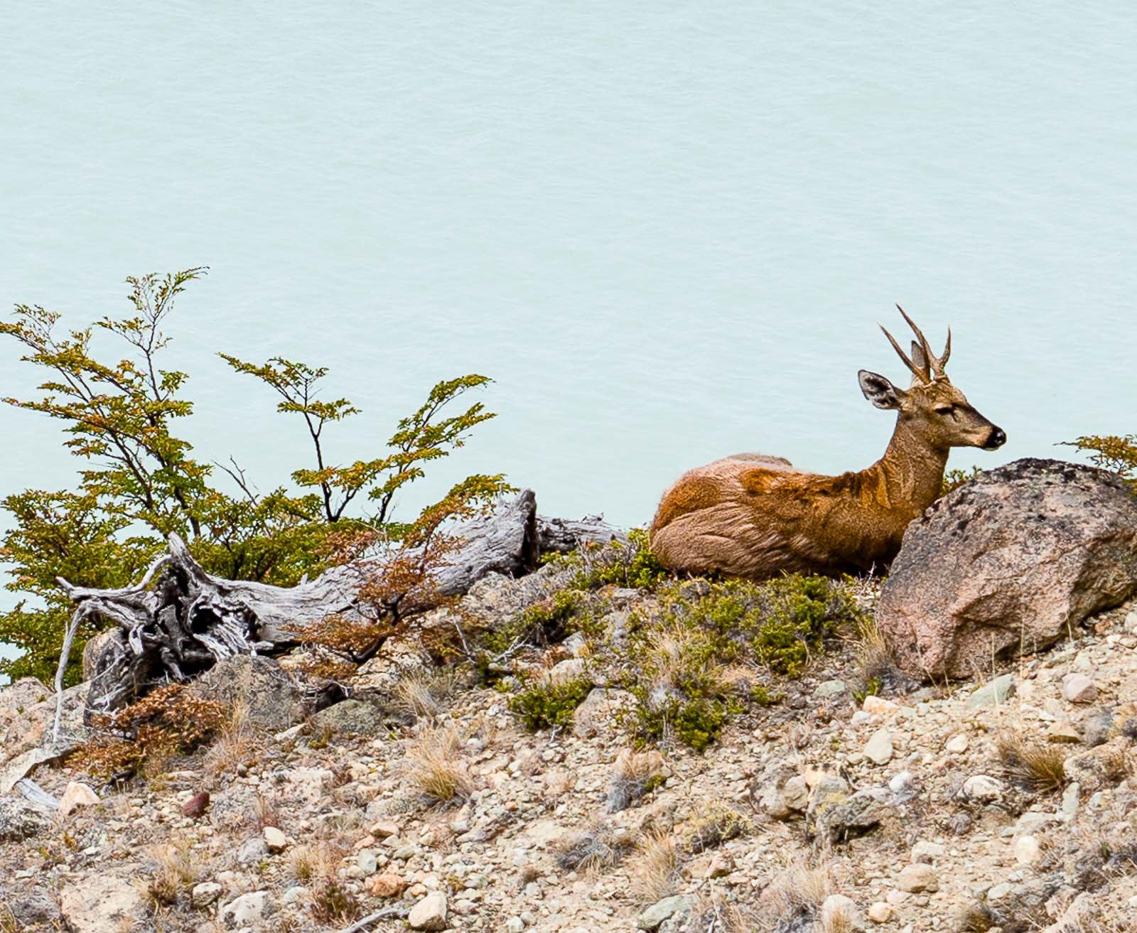
Living up to its name, the Huemul Circuit is the only place we’ve seen this endangered Andean deer in over 15 years of hiking in Patagonia. The Huemul (South Andean Deer) population is estimated to have suffered reductions of 99 per cent in size and more than 50 per cent in distribution range. So keep your eyes open for a rare sighting!
The Details: The Huemul Circuit Trek
Navigation and Maps
GPX File – Our excellent GPX file of the Huemul Circuit Hike is the easiest and best way to navigate on this hike. We highly recommend you use this .gpx file with GAIA GPS (20% off this site) and the two map-layers “Gaia Topo (feet)” and “MapBox Outdoors HD.” For more info on using GAIA see How to use your Smartphone as the Best Backpacking GPS.
Note: We are happy to have you use this .gpx file for your personal use. But please respect our work and do not distribute or share it with others.
And of course you should pick up one of the better paper maps in town. The “Chalten trekking map” by Chalten Outdoors Maps is nice. Or you can get El Chalten Trekking Map Monte Fitz Roy & Cerro Torre… Topographic Map January 1, 2018 on Amazon.
Logistics
The trek starts in El Chalten, Argentina. This 4-day trek requires a free permit that you can get at the Park Visitor Office (which you pass as you come into town). To get the permit, you will need to show that you have the following gear. See below for the posting on the wall at the Park Headquarters:
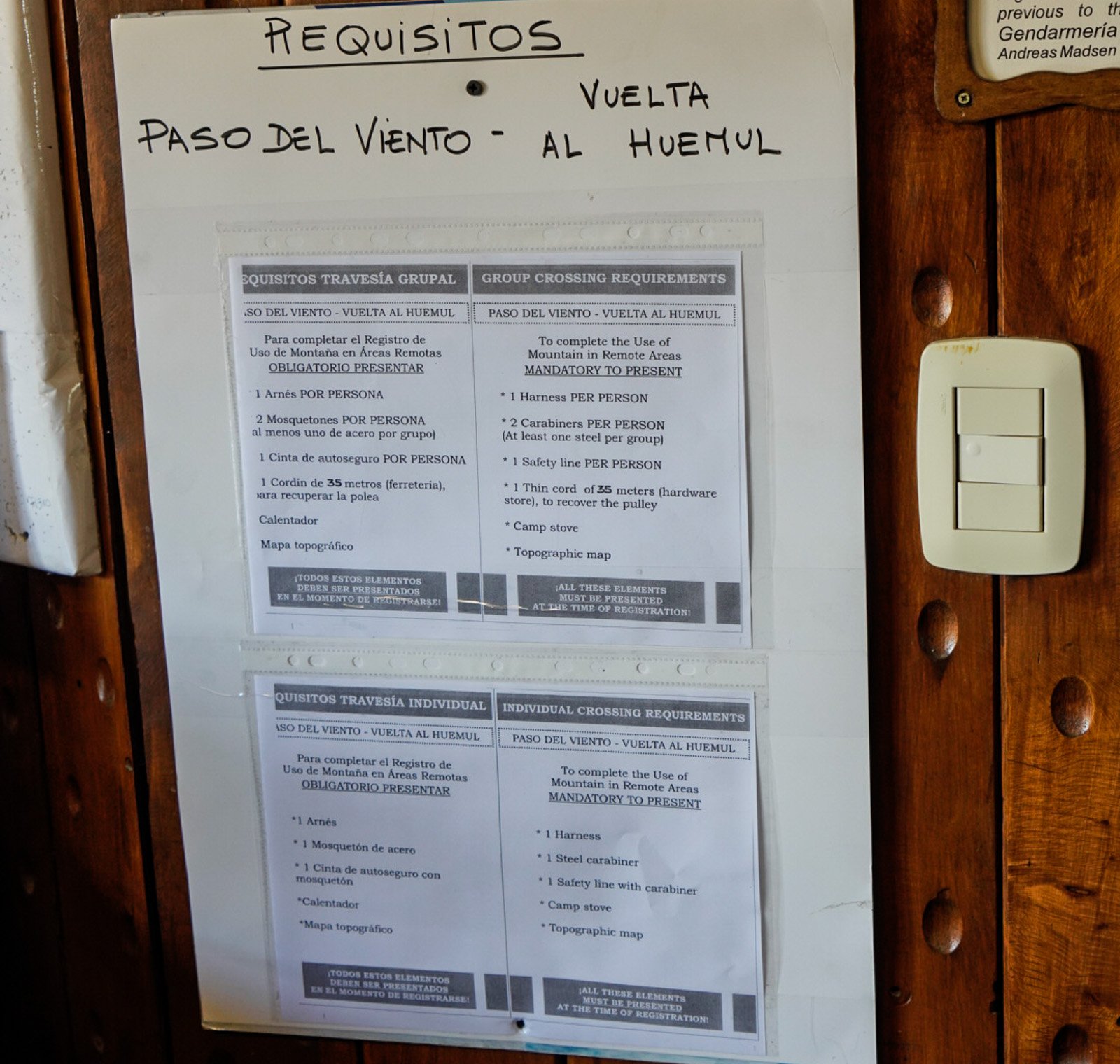
The Park Visitor Center is open 9am-5pm, September – April and 10am-5pm, May-August. All gear can be rented at outfitters in town although we recommend bringing most of your gear with you. It will likely be lighter and less well-used than rental gear and save you some money. The only exception to this rule is that you might want to rent the gear for a tyrolean traverse.
Details of Backcountry/Wild-camping and Campgrounds
Backcountry camping: There is only one backcountry hut on the trek (at the Paso del Viento campground) and it is for cooking only. The only backcountry outhouse was at Laguna Toro which made it the cleanest and most sanitary of the camps. Wild camping is not allowed in the park — stay at the campgrounds. And besides with the ferocious patagonian winds, you really do want to be in an established and protected campsite.
Campgrounds: As noted, there are few outhouses, no picnic tables, or other amenities. There are wood windbreaks at some tent sites for Campamento Laguna Toro. And there are stone windbreaks at some tent sites for Campamento Paso del Viento (and the nearby Campamento Laguna Ferrari). Most of the campsites at Campamento Bahia de los Tempanos are well protected in the trees, but there are not that many sites. Overflow camping is at Campamento Bahia de Hornos).
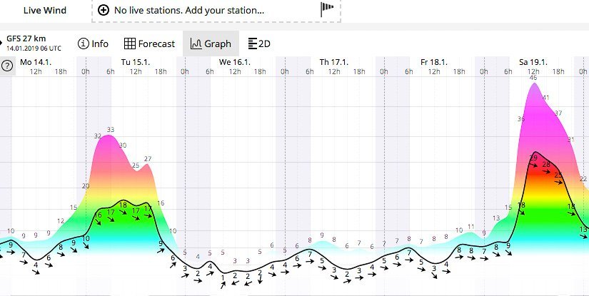
Sample wind forecast from WindGuru showing a 3-day weather window, Wednesday to Friday, with low winds where going over Paso de Viento and Paso Huemul would be possible.
Weather
The legendary Patagonian winds routinely blow 60 too 100 miles per hour and can literally stop you in your tracks, making it impossible to move forward or even stand upright. This trek has two passes that cannot be crossed in high winds. On Day 2 you cross Paso de Viento and on Day 3, Paso Huemul. As such, finding a window of low winds for these passes is critical for a successful trip. It is exceptionally unwise to just hope that you get lucky at these passes. You’ve paid too much money to get to Patagonia. So plan accordingly with WindGuru and ensure you have a pleasant and successful trek.
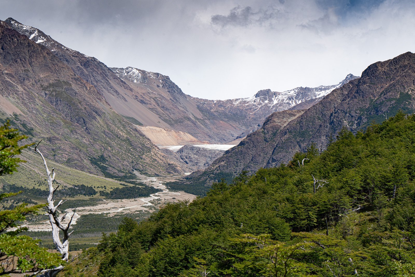
View of Valle Tunel. Paso del Viento is the obvious low point in the far distance. The route goes along the left side of Glacier Rio Tunel Inferior (center of pic) and then up the loose rock and scree of the lateral moraine of the glacier. Camp for Day 1 is at Campamento Laguna Toro, near the white dot in the geometric center of the picture.

Day 1: El Chalten to Laguna Toro Campground
16 km (10 miles) | 760m (2490 ft) ↑ | 490m (1620 ft) ↓
The start of the trek is at the Visitors Center so you can efficiently grab your permit and head off on your hike. Or, if you’d like to leave early, picking up your permit the night before is an option. Often times the first day of a trip’s sole purpose is to position you for the rest of the trip. This is exactly day one of the Huemul Trek. For us, that meant starting the trek in horrendous weather to get the gorgeous weather window coming the next few days. Day one has a moderate ascent on a well-marked trail with great views of Monte Fitz Roy and the crest of the Southern Andes, so enjoy the views if you get them. While there are a few signs along the way the .gpx trek (see below) will make sure you stay on course as you will pass several paths heading off in other directions.
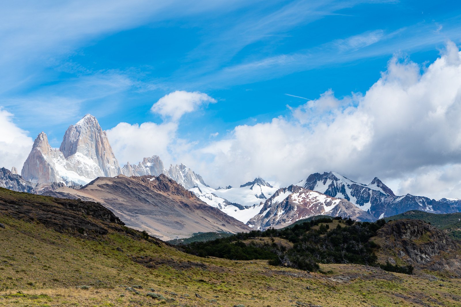
You get great views of Monte Fitz Roy on the hike out of El Chalten en route to Valle Tunel and Campamento Lago Toro.
The campground at Laguna Toro is well marked and well laid out. Water is found another 50 meters further along the path. Weather Tip: Because of the famous Patagonia winds, try to get a spot as far back in the trees as you can.
If you get to camp early enough, you may want to scout for Day 2 a bit, especially to locate the tyrolean traverse.
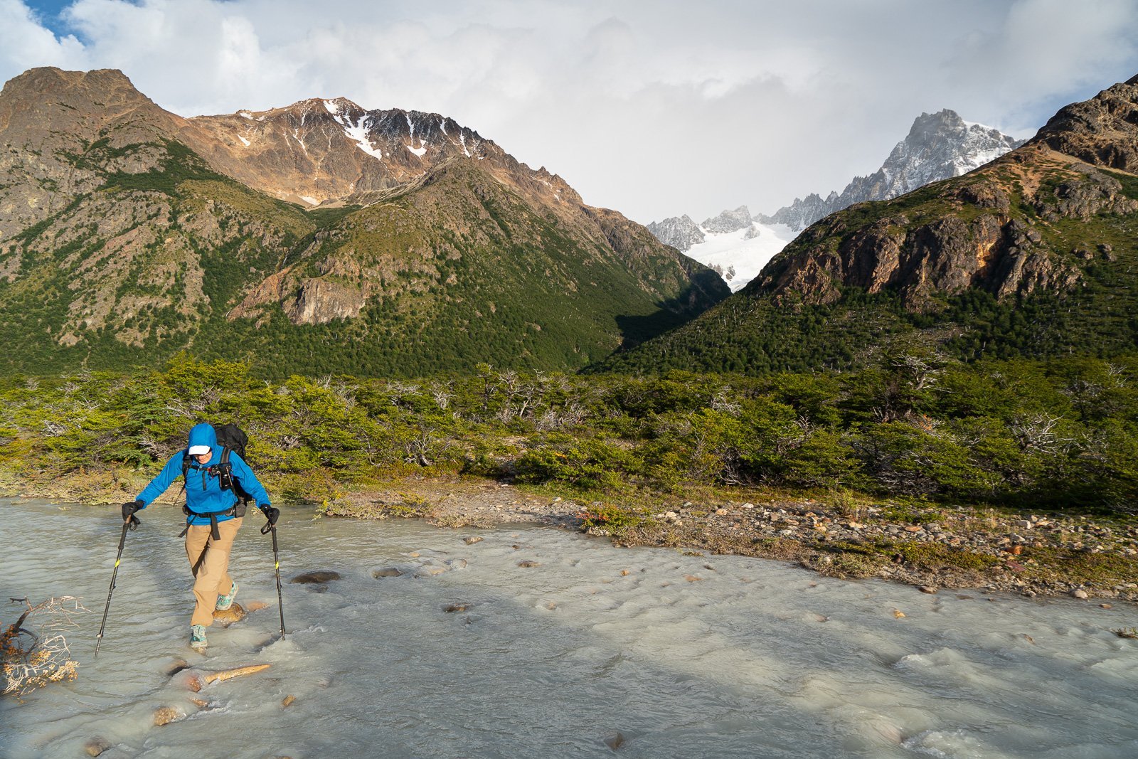
Heading up Valle Tunel you have a number of small to moderate wades across cold glacial fed streams.
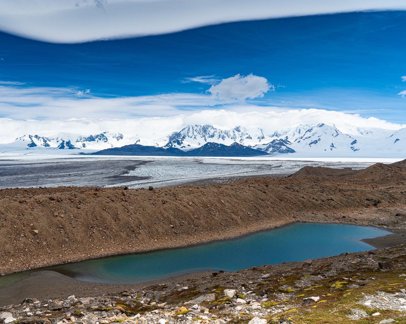
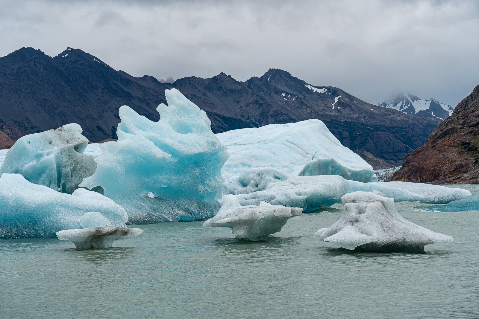
View of of the Southern Patagonia Ice Shelf and the start of Glacier Viedma as you come down from Paso del Viento. Lago Ferrari in the foreground.
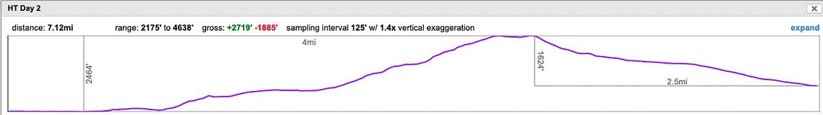
Day 2: Laguna Toro campground to Paso del Viento Campground
11.5 km (7.1 miles) | 830 m (2720 ft) ↑ | 570 m (1890 ft) ↓
Day 2 needs to be a good weather day (i.e. low wind) as you will be crossing Paso del Viento. Begin the day following the use trail to the right side of Laguna Toro. At the dry end of the lake, follow cairns up the rocks to a small lake. At the small lake, the trail turns south to meet the Rio Tunel. The tyrolean traverse is slightly downstream of where the footpath meets Rio Tunel. We have waypointed its location in the .gpx file as we had a number of reports of folks not being able to find it.
There are several YouTube videos on how a tyrolean traverse works (and the guide shops can give you instruction as well when you rent the gear). Please make sure to take off your backpack before crossing. It should NOT be on your person during the tyrolean traverse. We saw at least one person get stuck with their pack pinning them to a position in which they could not move. That said, hikers did it all the time and we cringed each time we saw it.
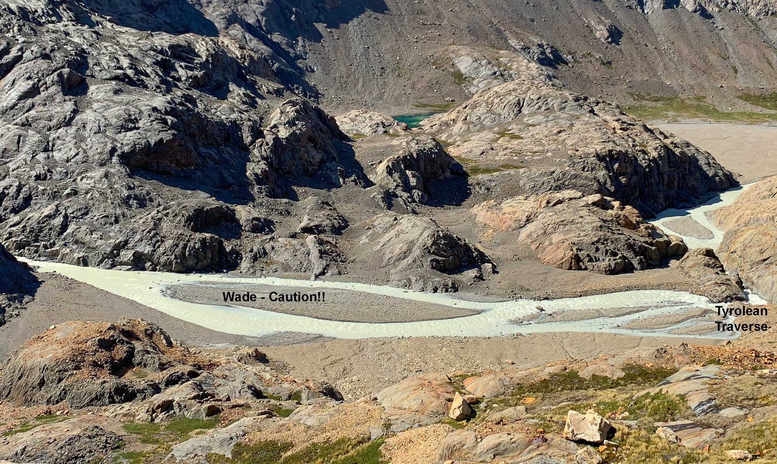
Birds eye view of the crossing of Rio Tunel above Laguna Toro (taken after we had crossed). The required (and by far the safest) method to cross is via the tyrolean traverse indicated on the right. Other hikers and some of the guide shops in town suggest that early in the morning before the sun warms the glacier and raises river levels, that it is possible to wade the braids above the traverse. Of course this requires experience in wading high rivers, strong legs, trekking poles and good judgement — as such we cannot recommend it.
View is looking up towards Paso del Viento with Glacier Rio Tunel Inferior on the right. Trail cairn in lower left. As you can see the trail is not very distinct in places.
The trail gradually ascends across a lateral moraine thru scree and talus along the side of the glacier (or you can hike on the glacier). Then it climbs above the glacier towards the pass. Follow the footpath and cairns to the Paso del Viento. Relying on the attached .gpx file will assist you in taking the most efficient route. [Again this route is likely to change a bit every year…]
There are several breathtaking views in Patagonia of the Southern Patagonia Ice Shelf as you go over Paso del Viento. For miles and miles (in fact, at some point, over 50 miles wide), the Southern Patagonian Ice Field spreads out like a sea of white ice and snow. This view of the ice fields stays with you while you descend from the top of the pass. At some point during your descent, you enter grassy slopes and valleys. that eventually brings you to the Paso del Viento campground. The campground has eight walled campsites up against a steep slope (for wind protection). The same weather tip applies: pitch your tent as close to that hill as possible for protection from the wind. There is a cooking hut at this campground. This campground has no latrine so please be very conscious about human waste.
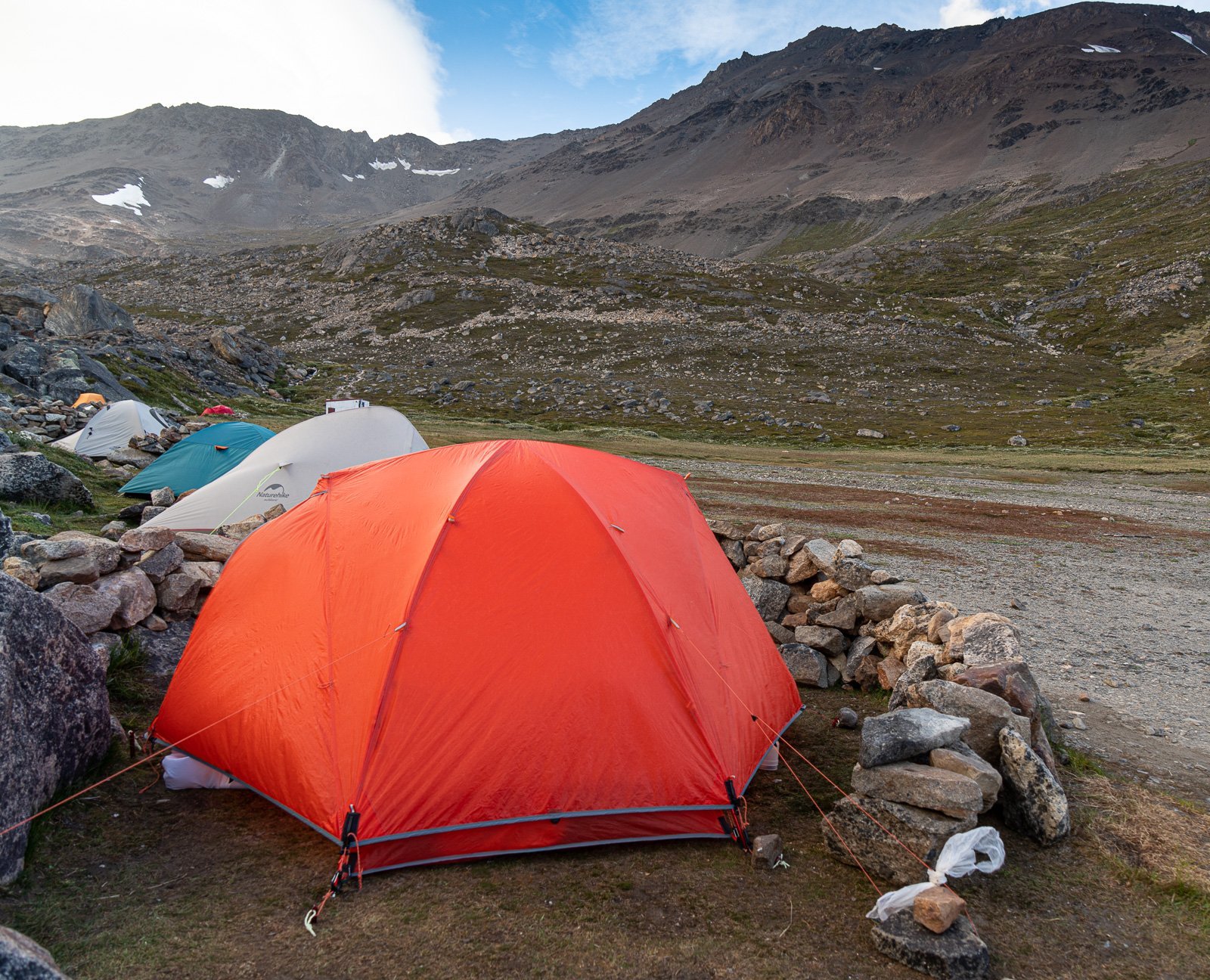
Stone windbreaks at the tent sites for Campo Paso del Viento. It is well advised to make use of these protected tent sites at every opportunity. The last thing you want is for your tent to be pitched out in the open when winds start gusting to 60 mile per hour. All but the most serious mountaineering tents will fold!
Climbing up Paso Huemul. This turned out to be a very windy day and near the top of the pass we were barely able stay upright in the stronger wind gusts.
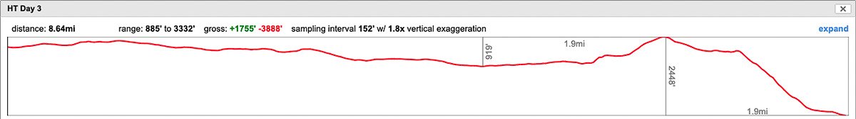
Day 3: Paso del Viento Campground to Lago Viedma Campground
14 km (8.7 miles) | 535m (1760 ft) ↑ | 1190m (3890 ft) ↓
You need another fairly good weather window today to go up and over over Paso Huemul. While the pass is not too difficult, it will be very difficult if the wind kicks up. There is a little bit of scrambling to get up the pass but really, not that difficult. The trick for today is to make sure you only have food for this day and the last, as you need to be as light as possible to descend the other side of Paso Huemul.
The Descent
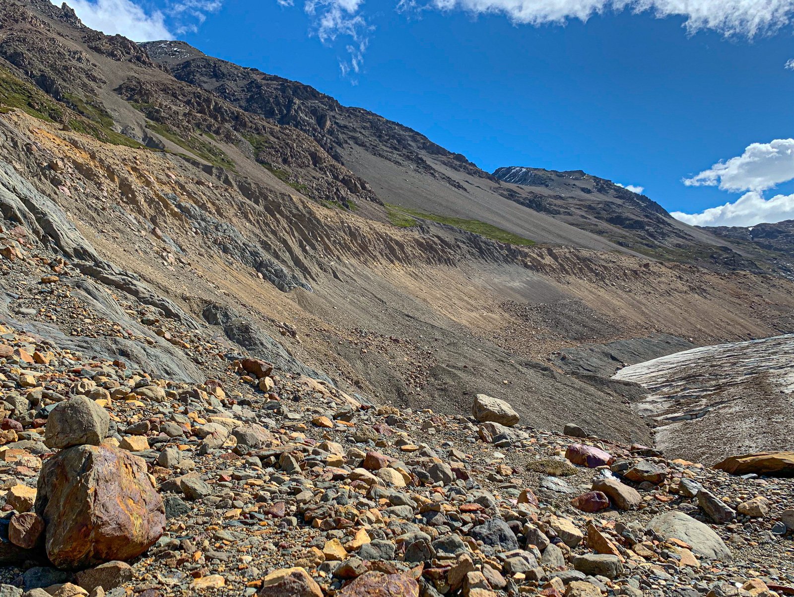
The descent from Paso Huemul to Lago Viedma gets its own section. This descent is what makes trekking poles mandatory. The main problem is a poorly maintained and massively eroded trail. This manifests as very steep sections, made super slippery on a thin layer of cruddy eroded rock and dirt on top of a harder surface. A bit like marbles on a tile floor. While there are some trees to hold onto, for the most part, your quads are doing the work. The only good part about this descent is that you are in the trees and therefore, wind is not a factor. At one point, we encountered a skanky hand rope to assist over a 15 to 20 rock cliff. After using it, we discovered it was precariously tied into a somewhat iffy tree, and if we had to do it again, would probably not of used that rope. Watch carefully where you are going and what you grab onto. Take it as slow as you can.
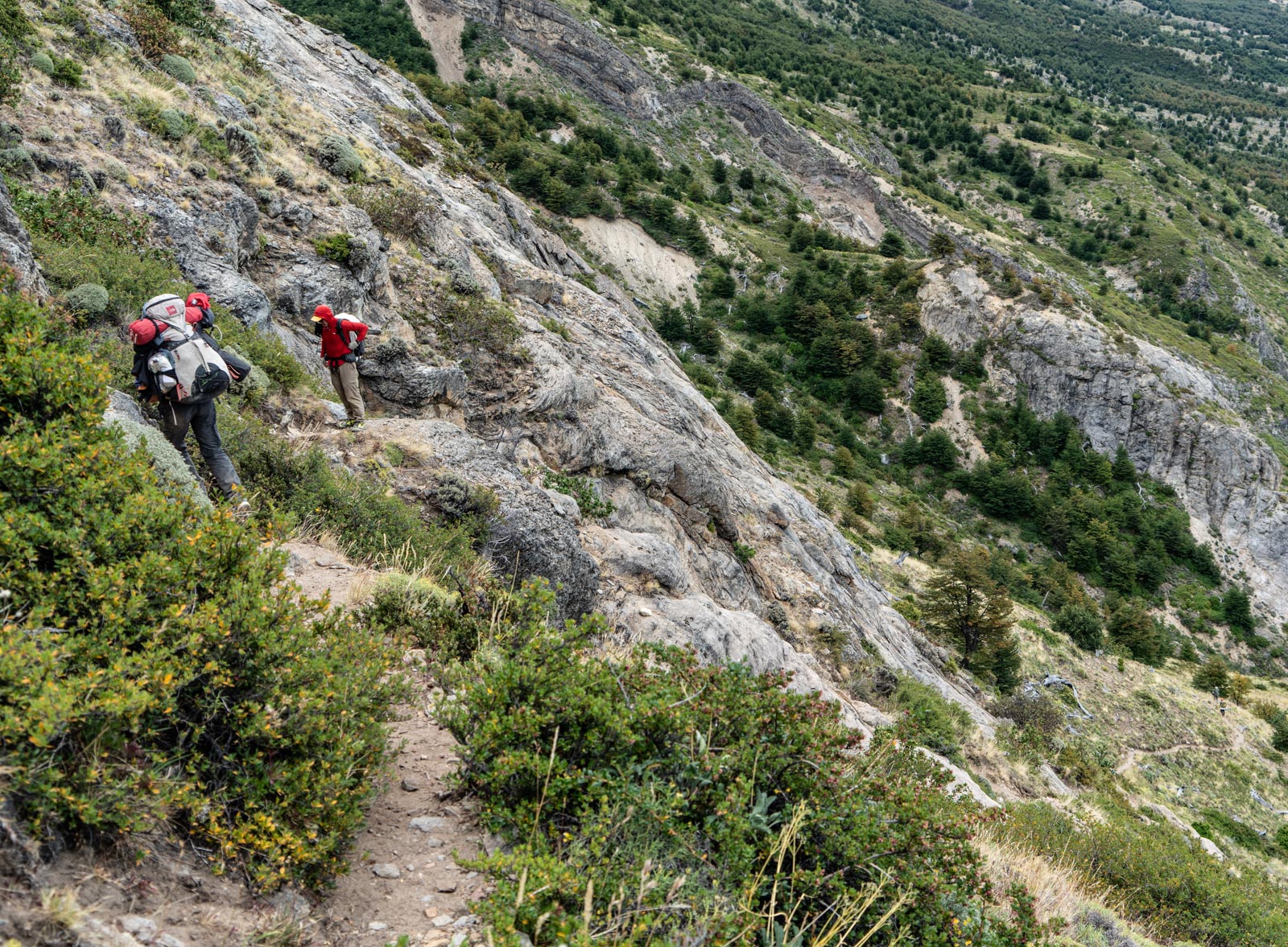
Alan on the descent. Note extreme slope.
Once you clear the worst of the descent (it becomes evident), you will continue downhill at a much more manageable grade. The icebergs of Bahia de los Tempanos become visible and larger as you get closer to them. Keep your eyes open for the elusive huemul.
Our only huemul sighting in 15 years of hiking in Patagonia was on this descent.
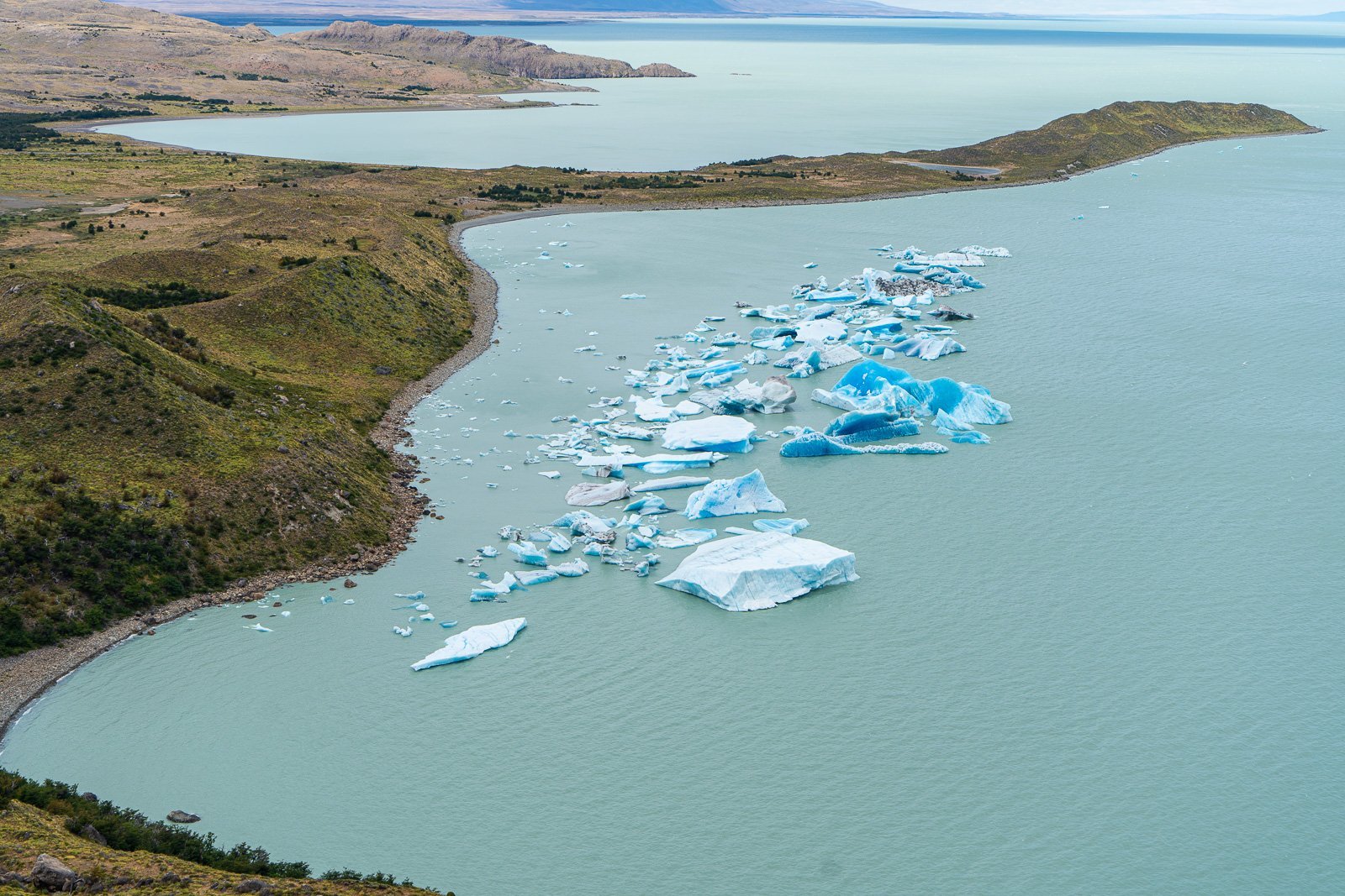
Campamento Bahia de los Tempanos is in the trees on the lower left.
Your options for camping are fairly plentiful around both Bahia de los Tempanos and Bahia de los Hornos (you have two options). If you camp around the icebergs, you can listen to them cave all night. If you want to stay away from the crowds, head to the Hornos. We choose to camp at the Tempanos because it allowed us to tuck into the trees, and away from the wind and although crowded, there was plenty of room for us.
View from Campamento Bahia de los Tempanos. We listened all night to these huge icebergs calving smaller icebergs!
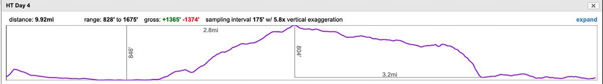
Day 4: Lago Viedma to Bahia Ferry Tunnel Dock
16 km (9.9 miles) | 420 m (1370 ft) ↑ | 420 m (1370 ft) ↓
This last day is fairly straightforward on relatively easy trails with only the tyrolean traverse over Rio Tunel. That said, stick close to the .gpx track as you do not want to end up in the swampy and/or brushy areas. There is a maze of trails here both legit and use-trails. It is also easy to get off trail entirely in deep brush. Pay attention!
Avoid brush, and muck. Stick close to the shore and follow the .gpx trek to not get mired in this.
The crossing over Rio Tunel is serious and where the trail meets the rivers, you’ll need to use the tyrolean traverse. (There are rumors that it is possible to cross the braided section of the river below the traverse, but as high as the river was, we’d guess it would be super sketchy at best. And of course you already have the required gear to do the tyrolean traverse.). So you will need to pull out your gear, hook up to the wire, and cross along with the other hikers.
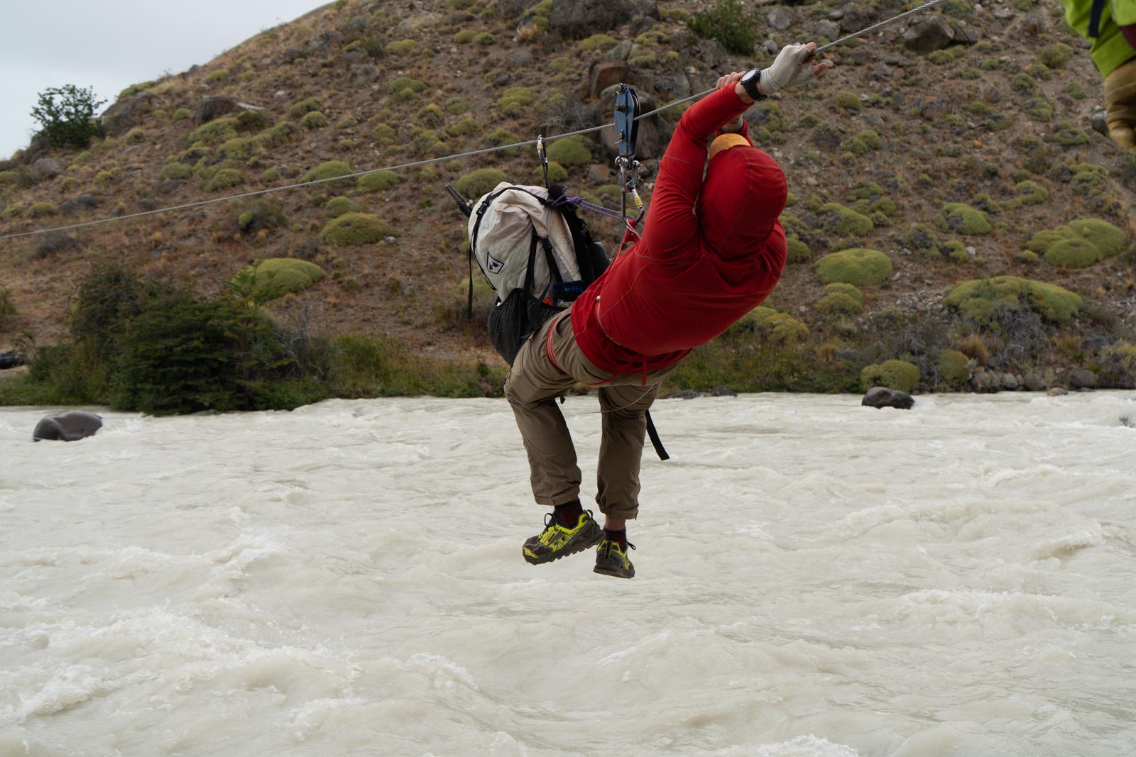
Alan on the final tyrolean traverse. Rio Tunel was a super scary, raging torrent of water when we crossed.
After the traverse, it is a short walk to the ferry terminal. You will notice a big beautiful boat sitting empty at the terminal. Apparently, the caving of the glaciar Viedma has led to the cessation of the boat and its tourist business.
From the terminal, you still need to get back to El Chalten. Your options are to arrange a ride ahead of time or hitch a ride back to Chalten. Alternatively you can walk some 8 km (5 miles) extra trail miles back to the Park Headquarters (it’s longer if you walk the road).
