A Very Different High Route – Escalante Overland Route
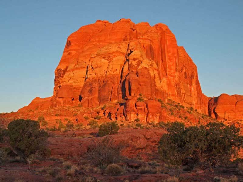
The Escalante Overland Route is arguably the most exciting high route in the lower-48! It is certainly the most beautiful and challenging trip we’ve done. The beauty of its remote desert canyons and mesas are equal to the best the planet has to offer, Grand Canyon included. Breathtaking views of red rock and the southwestern desert appear around every bend of the Escalante River.
The Escalante Overland Route (OLR) traverses the Grand Staircase-Escalante National Monument, arguably the best, true wilderness in the lower 48. Compared to the millions who visit the Grand Canyon each year, the vast expanse of the Monument below Highway 12 has no trails and few people. Many of the canyons only see a few visitors a year, if any. You are unlikely to see another person on the route. It is the perfect setting for a bona fide adventure filled with jaw dropping beauty.
Just to be clear, this is Steve Allen’s route. He describes an “Overland Route” in a few terse paragraphs at the end of a 1997 guide book. He presents it more of a challenge than a guide. In the ensuing 20 years it’s remained off the radar, with almost no known completions. In this sense, the OLR is closer to a “revived” route than a new one. Don Wilson, Andrew Skurka and I hope that this trip report will inspire more people to experience the wonders of the Escalante.
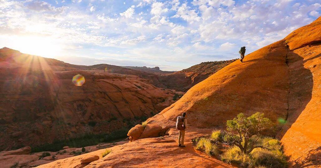
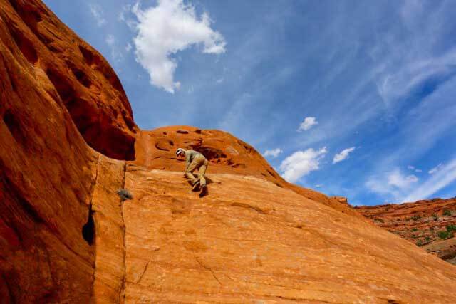
Lead photo: Author on dawn climb to Scorpion Bench. Andrew Skurka is next up. (Photo Don Wilson)
Alan’s photos: Sony a6000 with various Sony lenses (more on my camera setup here)
Don’s photos: Canon 5d with Canon EF 16-35mm f/4L IS USM lens
What is the Escalante Overland Route?
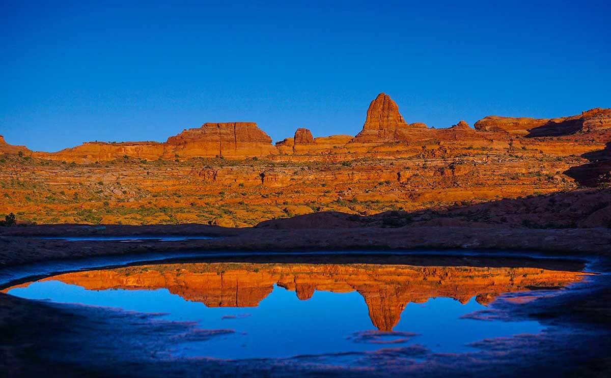
While millions gawk a the Grand Canyon each year, only a fortunate few will see this dawn view from a remote side canyon on the Escalante Overland Route.
The Escalante Overland Route is a stunning, “desert canyon high route.” In many ways, it is better or equal to the Grand Canyon and it certainly has fewer people. For about 100 miles, the OLR stays high above the Escalante River Canyon, holding close to the rim. And counterintuitively, following the rim above the canyon is far more challenging than walking down the canyon bottom. The upside is the amazing view when perched on the edge of the rim a thousand feet above the canyon.
The Escalante was the last river of its size to be discovered in the lower 48 states and the area was the last to be mapped in the lower 48. (So recent that the maps have a 1000 meter grid and UTM coordinates!) Today, only a few canyons such as Coyote Gulch and Neon Canyon see regular use. And some of the side canyons are so remote and inaccessible, that people only go there about once every 5 to 10 years.

What’s our next move? Don checking out maps high above the Escalante. Navigation is critical & at times beyond challenging.
Stats and Route Info
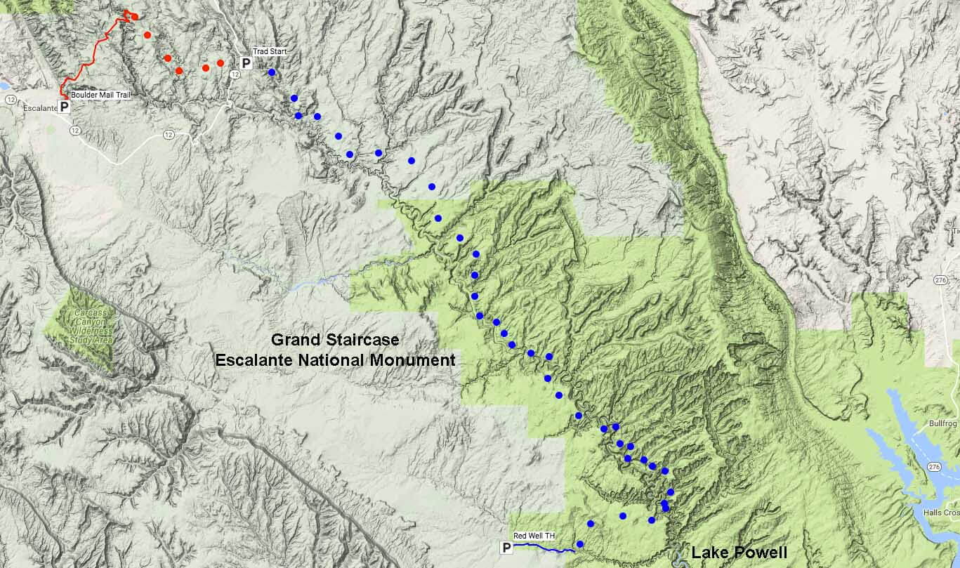
CLICK ON MAP TO ENLARGE: The 100 mile Escalante Overland Route Follows above the Escalante River all the way from the town of Escalante to where it enters Lake Powell. (The traditional OLR is in blue. The new addition is in Red.)
| Location: | Grand Staircase-Escalante National Monument, in Utah |
| Season: | Spring (April to mid-May) and Fall (mid-Sept thru mid-Nov) |
| Duration | 7 to 12 days. |
| Distance: | 100 miles (including the new addition)
|
| Navigation: | About as hard as it gets. It will confuse the heck out of you unless you are an expert navigating canyon country. And even then… |
| Physical: | Strenuous. No trails. Long walking on sand, uneven/broken terrain of all sorts, bushwhacking, unavoidable poison ivy, and a lot of scrambling/climbing. Expect low mileage days. |
| Technical: | Semi-technical: For experienced canyoneers that are also rock climbers. Somebody needs to be capable of leading a few of the climbing sections without protection. |
| Gear: | Sand-resistant shoes with tons of grip on rock. Lots of capacity to carry water. Climbing rope, harness, hardware and webbing to form anchors. (Depending on the time of year temperatures can vary from below freezing to 90s °F with intense sun.) A light pack is key to moving quickly and safely: Here’s a list of the 9 lbs of gear I took |
| Reference: | Steve Allen’s Canyoneering 3: Loop Hikes in Utah’s Escalante. The Overland Route description starts on page 306. |
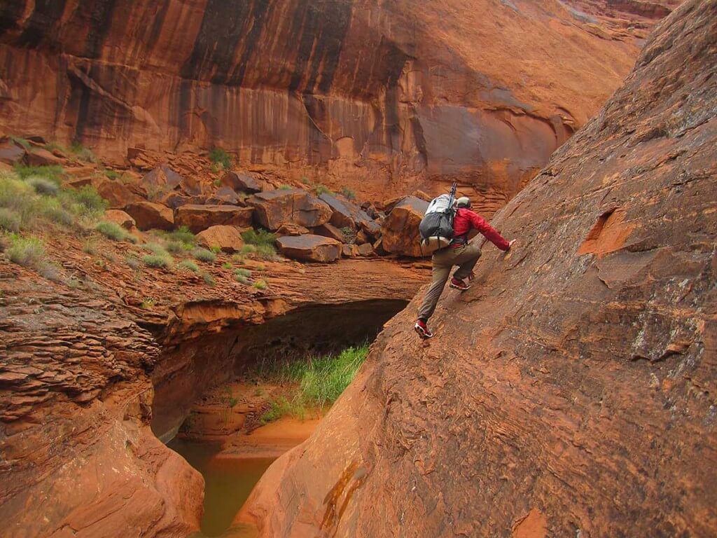
The Escalante Overland Route has risk. Some climbing is un-protectable on the smooth slick-rock. Author, free climbing in wet shoes over a pour-off (an overhanging cliff that blocks a canyon). A light pack is critical here! [photo Don Wilson]
Why is this a Trip Report and not a Comprehensive Guide?
While it’s exciting and beautiful, the Escalante Overland Route (OLR) may also be the most demanding high route in the lower-48. You have to earn the views and the solitude. This challenging terrain demands 100% of your attention. It also requires your absolute best physical, navigational, and scrambling/climbing abilities. It is not a route to be taken lightly.
The original intent was to publish a Guide and Mapset for the Escalante Overland Route. In 2015, Don Wilson, Andrew Skurka and I did the first half of the OLR. In 2016, Don Wilson and I went back and completed the route (Andrew had a schedule conflict). Don and I also scouted the last difficult sections of the new addition—crossing Sandy Creek and Calf Creek.
But in the end Don, Andrew and I agree with Steve Allen. The route is too challenging and dangerous for us, in clear conscience, to publish a comprehensive guide. In fact, a guide would ruin the intent of the OLR—a challenging and complex route to be relished and puzzled out on your own. So we opted for this Trip Report and Photo Essay.
That being said, we certainly don’t want to deter competent canyoneers from doing all or part of the route. People who are interested should read through the Challenges and Cautions for the Route section to assess whether this is something they want to undertake. If not, consider the easier, Non-technical Canyon Backpacking option below. But by all means get out into the canyons!
An Easy Introduction to the Wonders of Canyoneering
Many beautiful canyons are low risk – One can simply walk in and walk out. So, if you are interested in canyoneering but don’t know how, you might want to read my Non-technical Canyon Backpacking in Utah – a how to guide for getting started. There are a number of spectacular, but not difficult canyon systems waiting for you to explore.
Dawn near scorpion Gulch.
History of the Escalante Overland Route
The original “Overland Route” was proposed in 1997 by Steve Allen in a few terse paragraphs in the very back of his Canyoneering 3: Loop Hikes in Utah’s Escalante. He does not say that he’s done the route in any intentional way, although he certainly could have. And it’s almost 100% certain that Steve has done all portions of the OLR at one time or another on various trips.
But I’ve done a bunch of Google Searching and can find only a few mentions of using short sections of the OLR to connect-up a bit of terrain for another trip. As for the the complete OLR, I’ve found no records or trip reports or mentions, let alone a record or mention of someone successfully completing it. The only person I know who has done the complete OLR is Bill Wolverton and that was a number of years back. Bill recently retired, but he worked for the BLM in Escalante for many years. He is something of a local canyoneering expert and legend. According to Bill, he knows a few people who attempted the OLR, but is not aware of anybody completing it. They could have, but never reported back one way or the other.
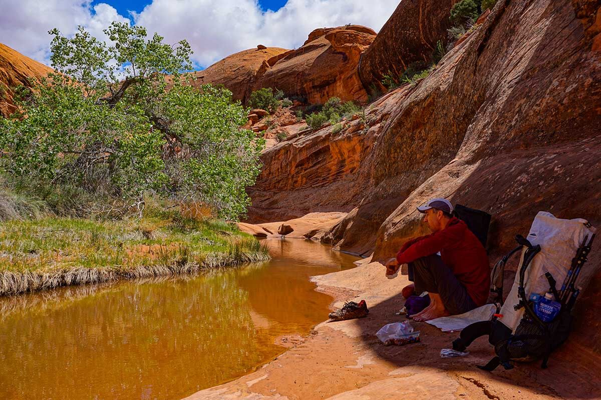
Water is scarce above the Escalante but sunlight and heat are plentiful. Don taking a break in the shade at a welcome opportunity to resupply our diminished water supply.
Brief Description
Allen’s Traditional Overland Route
The traditional 80 mile OLR (Steve Allen’s) starts on Route 12 near Calf Creek Falls and finally leaves the Escalante River Canyon just before Lake Powell. In between, it aggressively navigates across/around 10 major side canyons (and numerous smaller side canyons) as quickly as possible—many times with difficult-to-locate and challenging technical entrances and exits. It’s certainly the most difficult navigation that we’ve done.
New Extension – Start in the Town of Escalante
I’ve added a 20 mile extension to the traditional OLR. The extension starts on the historic Boulder Mail Trail (BMT) on the outskirts of the town of Escalante, Utah. This trail delivered mail by mule to Boulder, Utah until 1935—one of the last mule mail delivery routes in the US. The extension crosses the famous Box Death Hollow, before leaving the BMT to cross the major canyons of Sandy Creek, and Calf Creek. It joins Allen’s traditional OLR on Rt 12 about 2 miles south of the Calf Creek Falls Viewpoint. (Note: there are some more elegant and challenging ways to cross Box Death Hollow vs. the Boulder Mail Trail!)
Challenges and Cautions for the Route
Andrew Skurka down climbs a 5th class section of the route. (We had lowered packs using our rope.) [photo Don Wilson]
“It is not intended to be done in one push, although that would be an incredible accomplishment. [The Overland Route is] meant for those looking for remote and seldom-explored country… Most sections of the OLR are appropriate only for hardcore canyoneers that are also experienced rock climbers. Difficult climbing on steep walls, demanding route-finding problems, long distances between known water sources, and other assorted perils await the bold explorer…
The leader must be experienced with belay techniques and capable of leading the climbing sections without protection. Often the route descriptions are brief [or terse and vague to the point confusing and/or downright misleading]. You must be well versed in map reading and not be intimidated by long stretches of complex and convoluted terrain. You will not find the OLR marked on maps in this guide. The dedicated and adventurous will be forced to assemble the puzzle on their own… Warning: Do not take the OLR lightly. It is intricate, at times trying, and without a doubt dangerous.“
What We Did
All that being said, we managed the route without a belay. We only used our rope once, and that that was to lower packs so we could do a 5th class down climb without them (photo above). Others might have a very different take on risk and what to do. But Allen is exactly right on on two points:
- There are sections where somebody is going to need to climb class 4+ or low 5th class slick-rock without protection. This is usually down climbing which is less pleasant.
- The navigation is exceptionally hard.
A Few Parting Photos from the Route
Here are a few more photos to give you an impression of the Escalante Overland Route
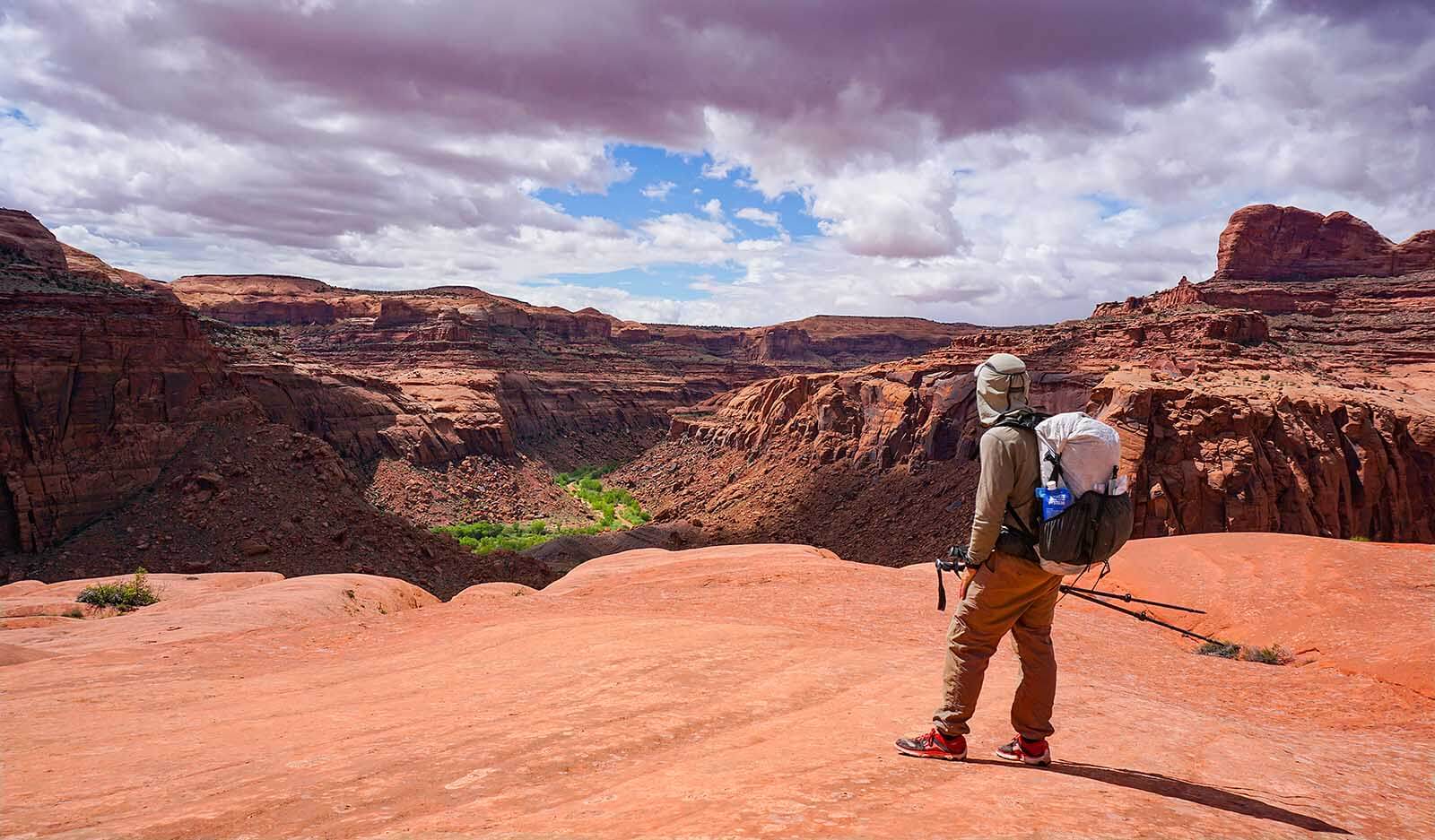
What the world looks like from the rim of the canyon. To give you a sense of scale, those tiny green dots in the canyon bottom are full sized cottonwood trees.

Dinner at typical camp in an extremely remote canyon. Practicing leave not trace, we just put down quilts down on the slick rock to sleep. Nobody will ever know if we were there.

Even in the desert getting wet is sometimes unavoidable.
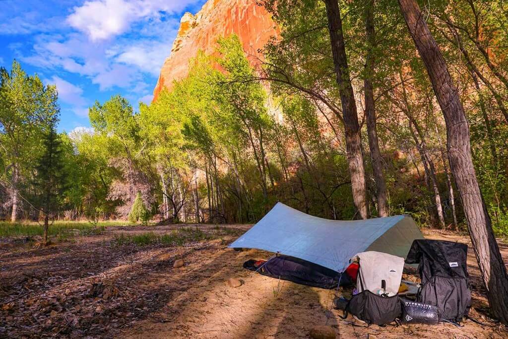
Tarps are perfect for the desert with its low chance of rain. They are a great way to save weight. Don and I only set ours up when there was a chance of rain, otherwise it stayed in the pack. See: Recommended Tents, Tarps and other Shelters

Dawn silhouette above the Escalante.
Thanks
And of course many thanks and gratitude to Don Wilson, Andrew Skurka for being great partners in this adventure. -alan


